In May 2025, India’s western and southern states, including Kerala, Karnataka, Tamil Nadu, Goa, and parts of Maharashtra, are experiencing intense rainfall, with some areas receiving extremely heavy downpours exceeding 20 cm in a single day. The India Meteorological Department (IMD) reported the early onset of the southwest monsoon on May 24, 2025, a week ahead of its typical June 1 arrival, bringing heavy to very heavy rainfall to the west coast and adjacent peninsular regions. This unseasonal deluge, coupled with reports of flooding and disruptions, has raised questions about the meteorological and climatic forces driving these events and their connections to global climate patterns.
The heavy rainfall is primarily driven by a combination of a tropical low-pressure system and intensified low-level jet streams, as noted by the World Meteorological Centre in Beijing. These systems are interacting with a northward shift of the Intertropical Convergence Zone (ITCZ), a band of low pressure near the equator where trade winds converge, fostering widespread cloud formation and precipitation stretching from the Arabian Sea to Indonesia. The IMD’s satellite imagery from INSAT 3DR on May 20, 2025, confirmed intense convective activity, with overcast skies blanketing Kerala, Karnataka, Goa, and South Konkan. Additionally, a depression over the east-central Arabian Sea and south Konkan coast has amplified rainfall, particularly in coastal areas.
This early monsoon onset and its intensity are influenced by several regional and global climatic factors. The IMD’s Long Range Forecast for 2025 predicted above-average monsoon rainfall at 105% of the long-period average, attributed to neutral El Niño-Southern Oscillation (ENSO) and Indian Ocean Dipole (IOD) conditions, which are favorable for robust monsoon activity. Reduced snow cover over Eurasia and the Himalayas, observed earlier in 2025, has also played a role. Less snow means more solar radiation is absorbed by the land, warming it faster and strengthening the temperature gradient between the continent and the ocean. This enhances the low-level southwesterly winds that carry moisture-laden air from the Arabian Sea and Bay of Bengal to India, fueling heavy rainfall.
Global warming, with 2024 confirmed as the warmest year on record by the World Meteorological Organization, has set a warmer baseline for 2025, with global mean temperatures exceeding 1.5°C above the 1850-1900 average. This warming increases atmospheric moisture capacity, as per the Clausius-Clapeyron relation, which states that for every 1°C rise in temperature, the atmosphere can hold about 7% more water vapor. This has led to more intense and frequent extreme rainfall events (EREs) across India, particularly in the western coastal regions, where short-duration heavy rainfall events have increased in recent decades. The warming of the Indian Ocean’s sea surface temperatures and heightened surface latent heat flux further contribute to the formation of intense convective systems, leading to heavy downpours.
The heavy rainfall in May 2025 also reflects broader changes in monsoon dynamics. Research indicates that global warming is weakening the historical inverse relationship between Eurasian snow cover and Indian monsoon strength, making monsoon patterns less predictable. Additionally, the increasing frequency of Western Disturbances—east-moving, rain-bearing wind systems originating beyond Afghanistan and Iran—has contributed to unseasonal rainfall in northern and northwestern India earlier in the year. While these disturbances typically peak in winter, their increased activity in 2025, linked to rising global temperatures, has compounded the rainfall in some regions.
India’s diverse topography amplifies these climatic effects. The Western Ghats, a mountain range along the west coast, trap moisture-laden monsoon winds, causing orographic lift that results in heavy rainfall in places like Mahabaleshwar, which receives about 5,600 mm annually, and Mawsynram in Meghalaya, the world’s wettest place with an average of 11,872 mm. In contrast, the leeward side of the Western Ghats experiences a rain shadow effect, with significantly less precipitation. The Himalayas also play a critical role by blocking cold Central Asian winds, keeping India warmer and enhancing monsoon activity, while the Thar Desert in the northwest attracts moisture-laden winds, contributing to the monsoonal regime.
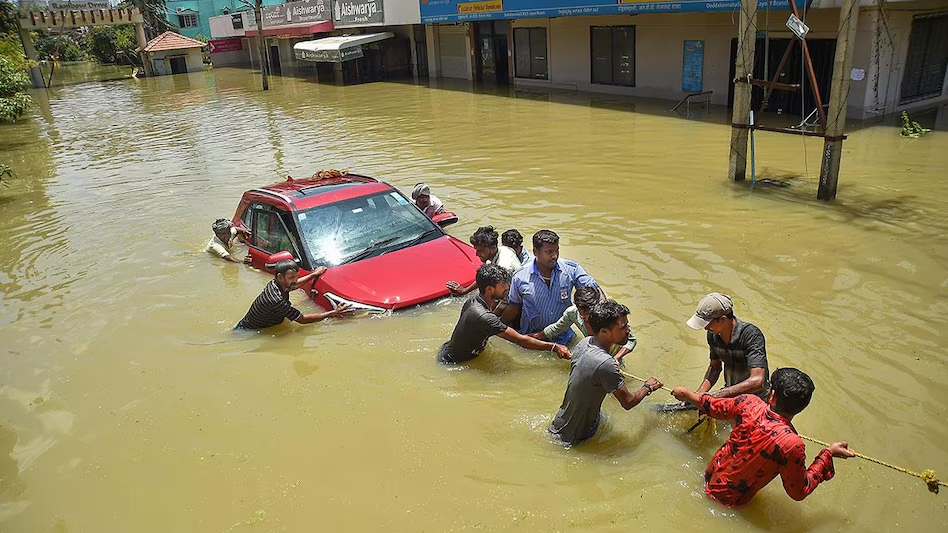
The impacts of this heavy rainfall are significant. Coastal and peninsular regions have faced waterlogging, flight disruptions, and localized flooding, particularly in urban centers like Delhi, where a Western Disturbance triggered heavy rains on May 2, 2025. Agriculture, which relies on rainfed systems for over 56% of India’s arable land, faces both opportunities and risks. While the monsoon supports crop growth, extreme rainfall events can damage crops, with studies showing a strong negative correlation between EREs and food grain yields. The economic toll is substantial, with hydrometeorological extremes accounting for 10% of global economic losses, approximately $3 billion annually in India alone.
Globally, the patterns observed in India align with broader climate trends. The increased frequency and intensity of extreme rainfall events are consistent with projections from the Intergovernmental Panel on Climate Change (IPCC), which warn of heightened hydroclimatic extremes under warming scenarios. The inability of current climate models, like those in CMIP6, to accurately predict short-duration heavy rainfall events underscores the need for improved forecasting tools to enhance disaster preparedness. As India navigates this wetter-than-usual May, the interplay of local geography, monsoon dynamics, and global warming highlights the complexity of its climate challenges and the urgent need for adaptive strategies to mitigate impacts.